
Pakenham, the visit
07 06 17 14:09 Filed in: Jim
Research is interesting and exciting as new snippets of information come to light. Our research into Pakenham, and our family’s important role in its history reached new heights when we decided to devote one of our Wednesdays to actually going there. Armed with a list of addresses and place names we drove there. Our plan was to go to all these places, but to begin with the site of the original settlement.
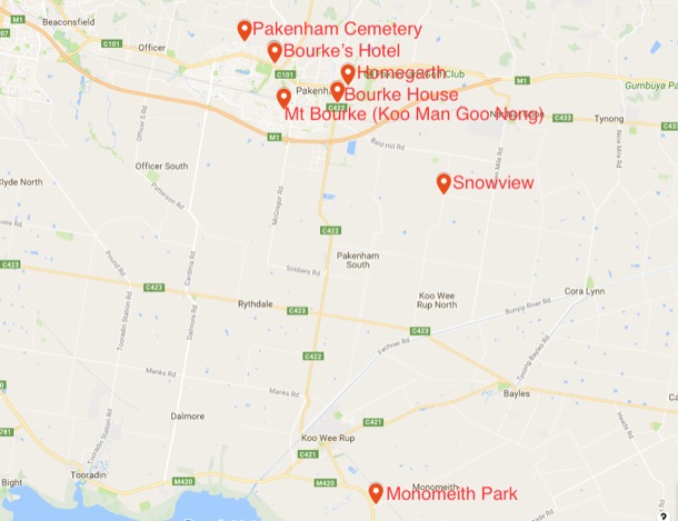
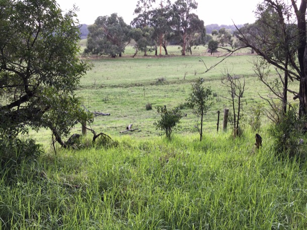
So, in May 2017, one hundred and seventy-three years after our great, great, grandparents Catherine and Michael Bourke selected Minton’s Creek Run, we stood on the very spot. In 1844 the area was probably grassy woodland, open country, well grassed and with shade for the cattle. Like in so much of Victoria, the early settlers, our great, great grandparents amongst them, could just take possession and let their stock loose. Today the area is still a pastoral landscape but obviously broken into smaller holdings. Minton’s Run appears to be quite hilly, rising from the creek to the foothills of the Dandenong Ranges in the North, and undulating to hilly country in the East and the West.
It must have been a hard life. The day we were there was cold, and after recent rain the ground was soft and muddy. Not much fun carrying water from the creek in this weather. Presumably Michael and Catherine’s bark hut would have been near this water source but up on the hill a little, safe from floods and away from the soggy creek flats. We walked a little way along the dirt road imagining Michael and Catherine building their bark hut, collecting water from the creek and tending their stock.
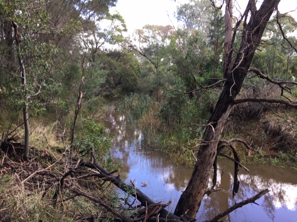
Turning south, we drove to Pakenham on the Toomuc Valley Road. It would have been an easy, flat, gallop downhill to the hotel site on the corner of what was, and still is, the point where the Princess Highway crosses the Toomuc Creek.
Not so easy for Michael, the day he galloped this way to rescue his family during the 1851 bushfires. Parking opposite the hotel, we walked the short distance to the creek, quite a substantial one, especially after rain. This is the spot where Catherine and the children sheltered from the flames, and where Michael found them safe and sound.
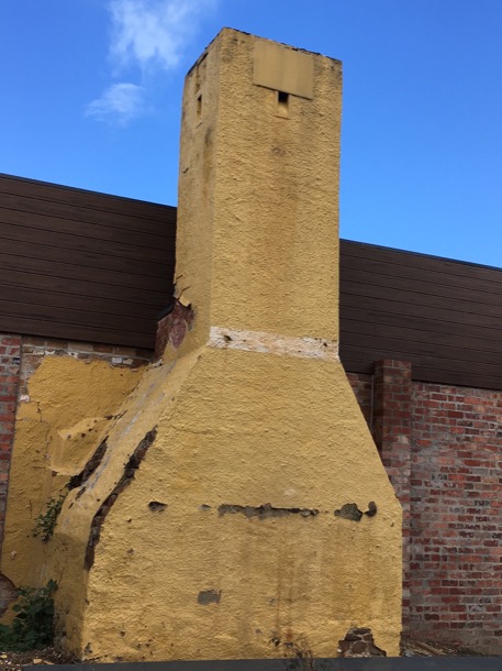
From this side of the road the heritage-listed original chimney is clearly visible. The hotel is undergoing yet another extension and renovation but the old bricks are just visible at the corner of the chimney where the layers applied over the years are crumbling away. Today the hotel is an ugly pile of add-ons and extensions including prominent Thirsty Camel drive through bottle shop. The chimney lives on, as does the business, obviously still thriving.
What next? As Pakenham Cemetery was nearby, we thought it fitting that we see where our great, great grandparents were buried. The cemetery is on a hill above the highway which was the main road to Gippsland, back when Michael and Catherine offered a stopping place to travellers. Nowadays, though still busy, and still called the Princes Highway, it is bypassed by the Princes Freeway.
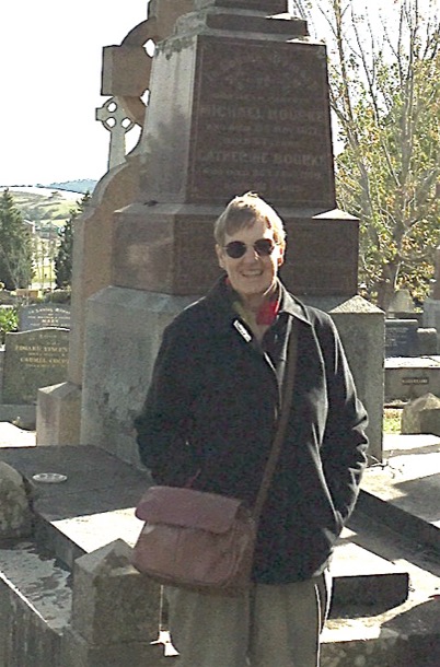
We had seen a picture of Michael and Catherine’s grave, and so had seen the shape of the cross on the top, but the picture had not shown where it was, nor had we been able to read the writing.
It’s not a very large cemetery and soon we found an area with various recognisable Bourke names.
We should have known just to walk to the highest spot! There was the patriarch towering above everyone else.

Michael and Catherine's grave:
Here is the original newspaper article about Michael’s death in 1877:
We regret to chronicle the death of Mr. Michael Bourke, the oldest inhabitant, as we understand, of Pakenham, whose remains were laid in the Pakenham Cemetery on Wednesday last. His death was accelerated by an accident, which, although it might have had but little effect on a younger man, hastened his end. A few days before his death he had gone up to the hay-loft of his stable to pull down some hay, and in descending the ladder missed his hold and fell heavily on the side of his head. At first it was not considered that be was much injured, but continued to get worse until be died. Although it rained almost incessantly during Wednesday the funeral was a very .large one, comprising most of the old residents for many miles around, by whom deceased was generally esteemed. About three o'clock the cortege started, the body being conveyed in a splendid hearse, followed by vehicles containing deceased's wife, daughters, and other female relations, his sons following; after whom came a number of vehicles, and, lastly a very long array of horsemen. The funeral service was conducted by Mr. D. J. Ahern, of Dandenong, in an effective manner, although during the ceremony the rain was falling very heavily. - From a first visit to the Pakenham Cemetery we cannot say much in praise; of the residents who permit it to remain in its present state so long. There are only five acres of it, which were granted by Government, and it is not creditable to the, residents to allow it to remain almost in its natural state.
The cemetery was very well kept on the day of our visit, and is clearly still in use today. We saw many names we recognised, such as James, Michael and Catherine’s eldest and his daughter Nellie, who had died, aged 17. We noted that four of Nellie’s uncles carried the coffin, including our great grandfather Michael, by then living in Melbourne.
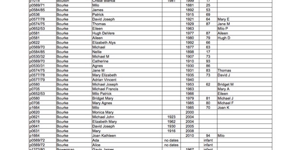
Here is a list of all the Bourkes buried in the Pakenham Cemetery:
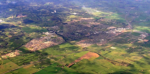
Looking down on the sprawling suburban growth that is now modern day Pakenham we could just see where another piece of Bourke history still stands, Bourke House. We drove down and pulled off the busy feeder road to the freeway into what will become the gateway to a new housing estate. It will eventually swallow the last vestiges of the first Pakenham Racing Club track that the Bourkes were instrumental in setting up. Today the track still visible surrounded by mud, trucks and cyclone fencing. Margaret and I approached Bourke House, right next door.
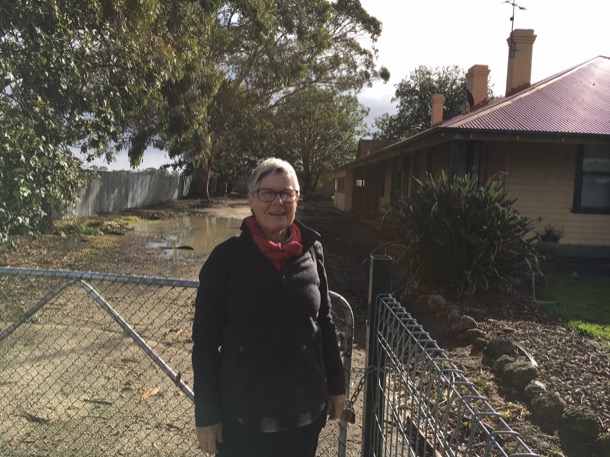
This racecourse residence and stable complex is heritage listed as it is a large, successfully designed and well-preserved residential complex from the 1920s, linked with a private racecourse and associated with notable district figures, such as the Bourkes, prominent Pakenham graziers and horse racing identities. Through its associations with the Bourke family who have played major roles within the Victorian Racing Club, and with the Pakenham Racing Club, this property has been significant in the history of racing in the shire.
The house and stables now sit behind a locked gate next to the sea of mud that was its racetrack. Hopefully when the housing estate is complete the house will also be tidied up and put to use again.
As we sat in the car, map in hand, we realised that, within walking distance of Bourke House, were several significant Bourke properties: the Bourke’s Hotel, the youngest son, David’s first property Homegarth, and the fifth son, Daniel Bourke’s Koo Man Goo Nong which he changed to Mt Bourke.
Homegarth and Mt Bourke have been absorbed into suburban Pakenham. Homegarth no longer exists, but the reminder of its existence is in the name of a playground and Childcare Centre nearby.
Mt Bourke is now a housing estate.
We drove and walked around the housing estate looking for acknowledgement of the history of the area, or directions to the original house. We found none and presumed that the house had been destroyed in the name of progress. But no, on the way home we were enlightened, at, of all places, the ‘Olivers' fast food outlet on the Monash Freeway. Collision of two worlds: as the chatty young lady passed us the coffee and egg sandwiches, she told us that she lived in that very estate, and yes, the house still stands at the top of the hill. Now the house looks down at the closely packed phoney heritage houses and other trappings such as Stockyards Playground, instead of productive fertile creek flats.
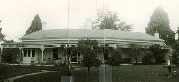
Koo Man Choo Nong/Mt Bourke:
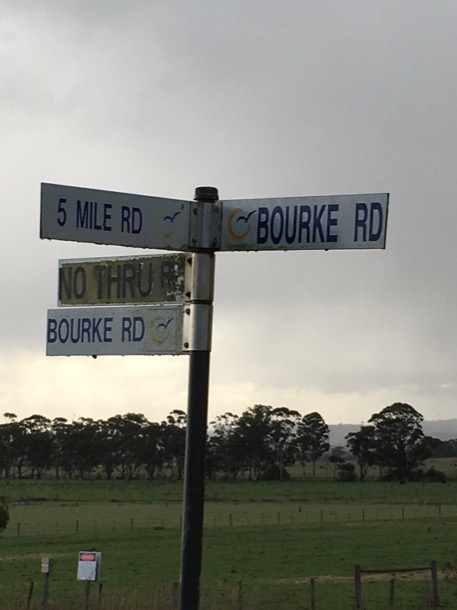
A little further out of town we found Snowview, owned by Thomas, Michael and Catherine’s third son. We could just see the ranges through the drizzle, a wonderful view. No wonder Thomas called his property Snowview. Still in family hands, Snowview is now an equestrian property. It stands at the corner of Bourke Road and Five Mile Road, and is bordered by very, very old, gnarled cypresses. Maybe Thomas planted these as a wind break from cold winds from the ranges?
It was getting late but we decided to attempt to find Monomeith, originally owned by David, the youngest son. Monomeith, still on the map, is situated on rich farming land at Nar Nar Goon. The roads were busy with trucks and commuters, very unpleasant driving conditions in the rain, but we soldiered on through several wrong turns, until we decided also to head for home. We now know, after further research, that we were very close. An excuse to go back another day.
So, in May 2017, one hundred and seventy-three years after our great, great, grandparents Catherine and Michael Bourke selected Minton’s Creek Run, we stood on the very spot. In 1844 the area was probably grassy woodland, open country, well grassed and with shade for the cattle. Like in so much of Victoria, the early settlers, our great, great grandparents amongst them, could just take possession and let their stock loose. Today the area is still a pastoral landscape but obviously broken into smaller holdings. Minton’s Run appears to be quite hilly, rising from the creek to the foothills of the Dandenong Ranges in the North, and undulating to hilly country in the East and the West.
It must have been a hard life. The day we were there was cold, and after recent rain the ground was soft and muddy. Not much fun carrying water from the creek in this weather. Presumably Michael and Catherine’s bark hut would have been near this water source but up on the hill a little, safe from floods and away from the soggy creek flats. We walked a little way along the dirt road imagining Michael and Catherine building their bark hut, collecting water from the creek and tending their stock.
Turning south, we drove to Pakenham on the Toomuc Valley Road. It would have been an easy, flat, gallop downhill to the hotel site on the corner of what was, and still is, the point where the Princess Highway crosses the Toomuc Creek.
Not so easy for Michael, the day he galloped this way to rescue his family during the 1851 bushfires. Parking opposite the hotel, we walked the short distance to the creek, quite a substantial one, especially after rain. This is the spot where Catherine and the children sheltered from the flames, and where Michael found them safe and sound.
From this side of the road the heritage-listed original chimney is clearly visible. The hotel is undergoing yet another extension and renovation but the old bricks are just visible at the corner of the chimney where the layers applied over the years are crumbling away. Today the hotel is an ugly pile of add-ons and extensions including prominent Thirsty Camel drive through bottle shop. The chimney lives on, as does the business, obviously still thriving.
What next? As Pakenham Cemetery was nearby, we thought it fitting that we see where our great, great grandparents were buried. The cemetery is on a hill above the highway which was the main road to Gippsland, back when Michael and Catherine offered a stopping place to travellers. Nowadays, though still busy, and still called the Princes Highway, it is bypassed by the Princes Freeway.
We had seen a picture of Michael and Catherine’s grave, and so had seen the shape of the cross on the top, but the picture had not shown where it was, nor had we been able to read the writing.
It’s not a very large cemetery and soon we found an area with various recognisable Bourke names.
We should have known just to walk to the highest spot! There was the patriarch towering above everyone else.
Michael and Catherine's grave:
Here is the original newspaper article about Michael’s death in 1877:
We regret to chronicle the death of Mr. Michael Bourke, the oldest inhabitant, as we understand, of Pakenham, whose remains were laid in the Pakenham Cemetery on Wednesday last. His death was accelerated by an accident, which, although it might have had but little effect on a younger man, hastened his end. A few days before his death he had gone up to the hay-loft of his stable to pull down some hay, and in descending the ladder missed his hold and fell heavily on the side of his head. At first it was not considered that be was much injured, but continued to get worse until be died. Although it rained almost incessantly during Wednesday the funeral was a very .large one, comprising most of the old residents for many miles around, by whom deceased was generally esteemed. About three o'clock the cortege started, the body being conveyed in a splendid hearse, followed by vehicles containing deceased's wife, daughters, and other female relations, his sons following; after whom came a number of vehicles, and, lastly a very long array of horsemen. The funeral service was conducted by Mr. D. J. Ahern, of Dandenong, in an effective manner, although during the ceremony the rain was falling very heavily. - From a first visit to the Pakenham Cemetery we cannot say much in praise; of the residents who permit it to remain in its present state so long. There are only five acres of it, which were granted by Government, and it is not creditable to the, residents to allow it to remain almost in its natural state.
The cemetery was very well kept on the day of our visit, and is clearly still in use today. We saw many names we recognised, such as James, Michael and Catherine’s eldest and his daughter Nellie, who had died, aged 17. We noted that four of Nellie’s uncles carried the coffin, including our great grandfather Michael, by then living in Melbourne.
Here is a list of all the Bourkes buried in the Pakenham Cemetery:
Looking down on the sprawling suburban growth that is now modern day Pakenham we could just see where another piece of Bourke history still stands, Bourke House. We drove down and pulled off the busy feeder road to the freeway into what will become the gateway to a new housing estate. It will eventually swallow the last vestiges of the first Pakenham Racing Club track that the Bourkes were instrumental in setting up. Today the track still visible surrounded by mud, trucks and cyclone fencing. Margaret and I approached Bourke House, right next door.
This racecourse residence and stable complex is heritage listed as it is a large, successfully designed and well-preserved residential complex from the 1920s, linked with a private racecourse and associated with notable district figures, such as the Bourkes, prominent Pakenham graziers and horse racing identities. Through its associations with the Bourke family who have played major roles within the Victorian Racing Club, and with the Pakenham Racing Club, this property has been significant in the history of racing in the shire.
The house and stables now sit behind a locked gate next to the sea of mud that was its racetrack. Hopefully when the housing estate is complete the house will also be tidied up and put to use again.
As we sat in the car, map in hand, we realised that, within walking distance of Bourke House, were several significant Bourke properties: the Bourke’s Hotel, the youngest son, David’s first property Homegarth, and the fifth son, Daniel Bourke’s Koo Man Goo Nong which he changed to Mt Bourke.
Homegarth and Mt Bourke have been absorbed into suburban Pakenham. Homegarth no longer exists, but the reminder of its existence is in the name of a playground and Childcare Centre nearby.
Mt Bourke is now a housing estate.
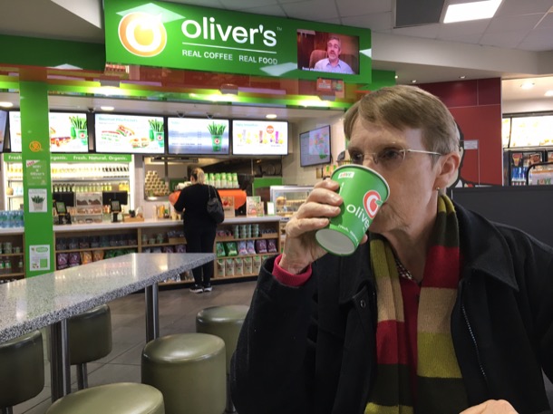
We drove and walked around the housing estate looking for acknowledgement of the history of the area, or directions to the original house. We found none and presumed that the house had been destroyed in the name of progress. But no, on the way home we were enlightened, at, of all places, the ‘Olivers' fast food outlet on the Monash Freeway. Collision of two worlds: as the chatty young lady passed us the coffee and egg sandwiches, she told us that she lived in that very estate, and yes, the house still stands at the top of the hill. Now the house looks down at the closely packed phoney heritage houses and other trappings such as Stockyards Playground, instead of productive fertile creek flats.
Koo Man Choo Nong/Mt Bourke:
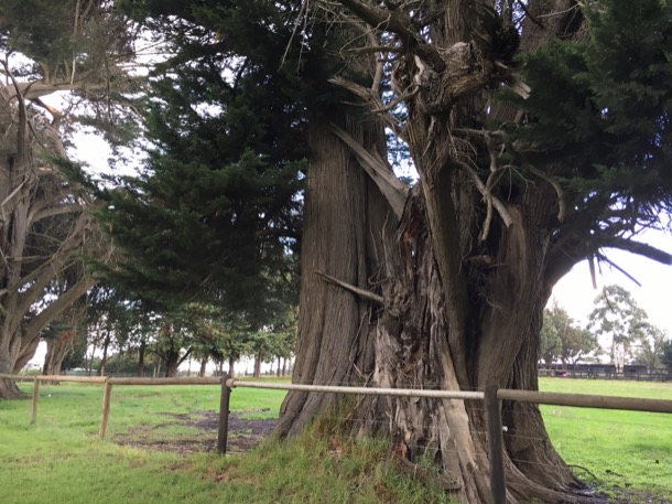
A little further out of town we found Snowview, owned by Thomas, Michael and Catherine’s third son. We could just see the ranges through the drizzle, a wonderful view. No wonder Thomas called his property Snowview. Still in family hands, Snowview is now an equestrian property. It stands at the corner of Bourke Road and Five Mile Road, and is bordered by very, very old, gnarled cypresses. Maybe Thomas planted these as a wind break from cold winds from the ranges?
It was getting late but we decided to attempt to find Monomeith, originally owned by David, the youngest son. Monomeith, still on the map, is situated on rich farming land at Nar Nar Goon. The roads were busy with trucks and commuters, very unpleasant driving conditions in the rain, but we soldiered on through several wrong turns, until we decided also to head for home. We now know, after further research, that we were very close. An excuse to go back another day.
blog comments powered by Disqus